
Kella
37308 Kella, Deutschland
Green Belt | Hiking & Cycling Path
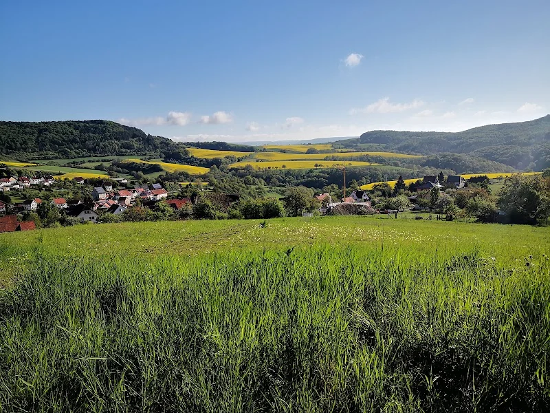
The Green Belt near Kella is not a traditional event location, but a natural and memorial landscape along the former inner-German border. Here, quiet paths, open greenery, border history, and an extraordinary biotope network come together. Those searching for Green Belt maps, hiking along the Green Belt, cycling paths, or GPX usually want this mix of orientation, nature experience, and historical depth. In Thuringia, the corridor is particularly significant: The Free State contributes 763 kilometers, the largest share of the Green Belt Germany, and the area has been protected as a National Natural Monument since December 19, 2018. ([naturpark-ehw.de](https://www.naturpark-ehw.de/gruenes-band?utm_source=openai))
Hiking along the Green Belt Thuringia
Those who want to experience the Green Belt on foot will find in Thuringia not a single standard product, but a dense network of paths, themed routes, and trail searching. The official site describes hiking trails that combine nature-based experiences with historical traces and are oriented towards the concept of the German Hiking Association. Quality, sustainability, and experiential value are at the center. This is exactly what makes this landscape appealing: One does not only hike through beautiful nature but moves in a region where landscape, memory, and the idea of protection belong together. The digital hiking track serves as a guide for individual tours along particularly striking landscape and historical sites and is especially helpful for guests who want to plan their route not just spontaneously but consciously. ([gruenes-band-thueringen.de](https://www.gruenes-band-thueringen.de/erleben/wandern?utm_source=openai))
Additionally, the special character of the terrain comes into play. At the Green Belt, hikers encounter relics of border history, open meadows, wooded edges, and sections that were once strictly secured. The official site lists typical elements such as remnants of border installations, observation towers, and river barriers. This mix of nature and history makes hiking so impressive: The path is never just movement but always also a search for traces. The Green Belt is suitable for both longer tours and individual day stages. Those who explore the region attentively experience how a former restricted area has developed into a place where recreation, education, and memory intertwine. This is also why the Green Belt Thuringia should not be viewed as a closed hiking trail but as a living landscape. ([gruenes-band-thueringen.de](https://www.gruenes-band-thueringen.de/erinnerungskultur/grenzrelikte?utm_source=openai))
Green Belt Cycling Path and EuroVelo 13
The Green Belt is also an extraordinary destination for cycling. The official cycling page states that the Green Belt Thuringia can be experienced in a special way on two wheels. According to EuroVelo, EuroVelo 13, also known as the Iron Curtain Trail, runs through Germany along the former inner-German border towards the Czech Republic. The German section is at the center of efforts to develop the former border area into a large green belt in the middle of Europe. This is doubly attractive for cyclists: They ride through quiet landscapes and through a historical space whose significance extends far beyond Thuringia. The trail thus follows not only a route but a historical line that once divided Europe and now connects it. ([gruenes-band-thueringen.de](https://www.gruenes-band-thueringen.de/erleben/fahrrad?utm_source=openai))
Cycling along the Green Belt therefore means more than just collecting kilometers. The route leads through diverse landscapes, past quiet memorial sites, and through natural areas that have preserved their special ecological quality since the end of the border. The official pages of the Green Belt refer to maps, stage descriptions, and information about the entire course of the trail, including in Thuringia. For visitors, this is a practical advantage, as it allows for good combinations of day stages, arrival and departure, and the appropriate connection between hiking and cycling. Those who discover the Green Belt by bicycle experience very directly how memory culture and gentle tourism interact. This is precisely where the strength of this route lies: It is open in terms of landscape, deep in history, and suitable for people seeking longer distances with meaning. ([gruenes-band-thueringen.de](https://www.gruenes-band-thueringen.de/erleben/fahrrad?utm_source=openai))
Map, Hiking Track, and GPX: How to Plan Your Tour
In a landscape area like the Green Belt, a good map is almost as important as good shoes. The official hiking page describes the digital hiking track as a guide for individual tours along particularly striking landscape and historical sites. This is especially sensible because the Green Belt is not a closed circular path but a corridor with many different accesses, sections, and uses. Those looking for a Green Belt map usually want to know where nature experiences, historical sites, and practical paths can best be connected. Here, official route pages help significantly more than a purely general search, as they make concrete routes, thematic focuses, and regional peculiarities visible. ([gruenes-band-thueringen.de](https://www.gruenes-band-thueringen.de/erleben/wandern?utm_source=openai))
A good example is the premium path P4 Hessische Schweiz. On the route, GPX and KML downloads are available, and the path is described as a 15.6-kilometer long, difficult circular route with about 5 hours and 30 minutes of walking time. The stations show how closely nature and border history are intertwined here: The path leads to viewpoints, through botanically interesting areas, and to historically significant places along the Green Belt. The station notes also list Kella as a nearby locality. For tour planning, this is a strong signal, as it immediately shows that the Green Belt is not just an abstract term but can be experienced well through concrete accesses, marked sections, and digital routes. Those who combine map and GPS can adapt tours much more precisely to their own condition, the season, and the desired experience. ([naturpark-ehw.de](https://www.naturpark-ehw.de/weg/premiumweg-p4-hessische-schweiz))
Kella and the Southern Eichsfeld
Kella is a clustered village in the southern Eichsfeld and lies on the edge of a landscape area that is particularly interesting for the Green Belt. The official local page describes that Kella borders Pfaffschwende to the north, Geismar and Großtöpfer to the east, and the Hessian municipality of Meinhard to the south and west. The Kellaer Bach flows through the village, which empties into the Werra in Hesse. Additionally, the location on the slope of the Gobert is emphasized, which is a ridge that opens up the view into the border region. This is important for visitors because here, the natural space, village structure, and historical border landscape overlap directly. Kella is thus not an isolated point on the map but a place that clearly shows how closely the region is connected to the former border course. ([naturpark-ehw.de](https://www.naturpark-ehw.de/ort/kella?utm_source=openai))
Especially in the vicinity of Kella, it becomes clear how practically the Green Belt can be experienced today. A hiking offer in the Eichsfeld-Hainich-Werratal Nature Park, for example, started at the Braunrode parking lot between Grebendorf and Kella and led as a nature and history tour along the Green Belt, including orchid observation and the storytelling of a contemporary witness. The premium path P4 Hessische Schweiz also connects the area by naming the Green Belt as a station and locating Kella nearby. From this information, it can be inferred that Kella is a very sensible starting point or intermediate space for hikers and nature enthusiasts. Those who start here experience not only landscape but also the transition between Hessian and Thuringian perspectives, between village life and border history, between nature observation and memory culture. ([naturpark-ehw.de](https://www.naturpark-ehw.de/veranstaltungen-reader/orchideen-und-geschichte-am-gruenen-band?utm_source=openai))
History, Border Relics, and Protection Status
The Green Belt is particularly significant because it has transformed a place of separation into a place of memory. The official memory page describes that at the Green Belt Thuringia, history can be experienced on paths, at towers, through border relics, and in the stories of people. Until 1989, the inner-German border divided Germany; today, the traces of the past remind us of life in the divided country. This duality is the core of the place: on one hand, a retreat for rare animals and plants; on the other hand, a memorial landscape of national significance. The transformation from a former death strip to a lifeline is thus not only a beautiful image but a historical reality that can be traced on site. ([gruenes-band-thueringen.de](https://www.gruenes-band-thueringen.de/erinnerungskultur?utm_source=openai))
The historical heritage mainly includes border relics. The official description counts buildings, paths, technical installations, and terrain structures of the former border security. Remnants of border fences, tank obstacles, foundations, clearings, and road alignments are still visible today. The column path, which is preserved in Thuringia for about 600 kilometers, is also particularly formative and serves today as a recreational path as well as part of the memory culture. To ensure that protection and mediation are not left to chance, a care, development, and information plan has been developed for the National Natural Monument. It governs protection, education, biotope networking, and public communication. This combination of documentation, care, and information makes the Green Belt a modern place of remembrance where nature conservation and historical education do not stand side by side but support each other. ([gruenes-band-thueringen.de](https://www.gruenes-band-thueringen.de/erinnerungskultur/grenzrelikte?utm_source=openai))
Green Belt Germany and Green Belt Europe
Understanding the Green Belt in Kella or Thuringia also means understanding a larger European system. The European Green Belt is the longest green network in Europe at 12,500 kilometers and connects 24 countries from the Barents Sea to the Adriatic and the Black Sea. The initiative describes it as a living document of shared European history that has emerged along the former border of the Cold War. For Germany, this means: The former border area is now part of a transnational nature and cultural heritage that strengthens ecological networks and connects local communities. ([europeangreenbelt.org](https://www.europeangreenbelt.org/european-green-belt?utm_source=openai))
In Germany, EuroVelo 13 runs along the former inner-German border, and the ecological and cultural-historical potentials of the border strip are visible in many regions. The official Thuringian presentation also emphasizes that the corridor not only protects habitats but is also being discussed as a potential UNESCO candidate. Since December 2023, the Green Belt Germany has been on the German UNESCO proposal list. For visitors, this is more than a prestige note: It underscores that this area is understood as a landscape of international significance. Those who hike or cycle here experience not only a regional nature project but also a piece of European time and natural history. This is where the special strength of the Green Belt near Kella lies: it is locally tangible, historically deep, and embedded in a large European context. ([de.eurovelo.com](https://de.eurovelo.com/ev13/germany?utm_source=openai))
For practical planning, this means: The Green Belt is worthwhile for people who think together about maps, hiking tracks, cycling routes, and historical backgrounds. It is a place for quiet tours, for conscious nature observation, and for both short and longer stages. The official pages provide hiking information, cycling information, memorial sites, and regional accesses. Thus, a search query for Green Belt maps, Green Belt hiking, or Green Belt cycling path becomes a real travel idea with substance. Those visiting the area around Kella find neither a loud major attraction nor an artificially staged theme park but a landscape that has emerged from history, protection, and movement. This authenticity makes the place so valuable. ([gruenes-band-thueringen.de](https://www.gruenes-band-thueringen.de/erleben?utm_source=openai))
Sources:
- Green Belt Thuringia - National Natural Monument ([gruenes-band-thueringen.de](https://www.gruenes-band-thueringen.de/nationales-naturmonument?utm_source=openai))
- Green Belt Thuringia - Hiking ([gruenes-band-thueringen.de](https://www.gruenes-band-thueringen.de/erleben/wandern?utm_source=openai))
- Green Belt Thuringia - Cycling ([gruenes-band-thueringen.de](https://www.gruenes-band-thueringen.de/erleben/fahrrad?utm_source=openai))
- Green Belt Thuringia - Memory Culture ([gruenes-band-thueringen.de](https://www.gruenes-band-thueringen.de/erinnerungskultur?utm_source=openai))
- Nature Park Eichsfeld-Hainich-Werratal - Green Belt ([naturpark-ehw.de](https://www.naturpark-ehw.de/gruenes-band?utm_source=openai))
- Nature Park Eichsfeld-Hainich-Werratal - Kella ([naturpark-ehw.de](https://www.naturpark-ehw.de/ort/kella?utm_source=openai))
- Nature Park Eichsfeld-Hainich-Werratal - Premium Path P4 Hessische Schweiz ([naturpark-ehw.de](https://www.naturpark-ehw.de/weg/premiumweg-p4-hessische-schweiz))
- European Green Belt Association - European Green Belt ([europeangreenbelt.org](https://www.europeangreenbelt.org/european-green-belt?utm_source=openai))
Mehr anzeigenWeniger anzeigen
Green Belt | Hiking & Cycling Path
The Green Belt near Kella is not a traditional event location, but a natural and memorial landscape along the former inner-German border. Here, quiet paths, open greenery, border history, and an extraordinary biotope network come together. Those searching for Green Belt maps, hiking along the Green Belt, cycling paths, or GPX usually want this mix of orientation, nature experience, and historical depth. In Thuringia, the corridor is particularly significant: The Free State contributes 763 kilometers, the largest share of the Green Belt Germany, and the area has been protected as a National Natural Monument since December 19, 2018. ([naturpark-ehw.de](https://www.naturpark-ehw.de/gruenes-band?utm_source=openai))
Hiking along the Green Belt Thuringia
Those who want to experience the Green Belt on foot will find in Thuringia not a single standard product, but a dense network of paths, themed routes, and trail searching. The official site describes hiking trails that combine nature-based experiences with historical traces and are oriented towards the concept of the German Hiking Association. Quality, sustainability, and experiential value are at the center. This is exactly what makes this landscape appealing: One does not only hike through beautiful nature but moves in a region where landscape, memory, and the idea of protection belong together. The digital hiking track serves as a guide for individual tours along particularly striking landscape and historical sites and is especially helpful for guests who want to plan their route not just spontaneously but consciously. ([gruenes-band-thueringen.de](https://www.gruenes-band-thueringen.de/erleben/wandern?utm_source=openai))
Additionally, the special character of the terrain comes into play. At the Green Belt, hikers encounter relics of border history, open meadows, wooded edges, and sections that were once strictly secured. The official site lists typical elements such as remnants of border installations, observation towers, and river barriers. This mix of nature and history makes hiking so impressive: The path is never just movement but always also a search for traces. The Green Belt is suitable for both longer tours and individual day stages. Those who explore the region attentively experience how a former restricted area has developed into a place where recreation, education, and memory intertwine. This is also why the Green Belt Thuringia should not be viewed as a closed hiking trail but as a living landscape. ([gruenes-band-thueringen.de](https://www.gruenes-band-thueringen.de/erinnerungskultur/grenzrelikte?utm_source=openai))
Green Belt Cycling Path and EuroVelo 13
The Green Belt is also an extraordinary destination for cycling. The official cycling page states that the Green Belt Thuringia can be experienced in a special way on two wheels. According to EuroVelo, EuroVelo 13, also known as the Iron Curtain Trail, runs through Germany along the former inner-German border towards the Czech Republic. The German section is at the center of efforts to develop the former border area into a large green belt in the middle of Europe. This is doubly attractive for cyclists: They ride through quiet landscapes and through a historical space whose significance extends far beyond Thuringia. The trail thus follows not only a route but a historical line that once divided Europe and now connects it. ([gruenes-band-thueringen.de](https://www.gruenes-band-thueringen.de/erleben/fahrrad?utm_source=openai))
Cycling along the Green Belt therefore means more than just collecting kilometers. The route leads through diverse landscapes, past quiet memorial sites, and through natural areas that have preserved their special ecological quality since the end of the border. The official pages of the Green Belt refer to maps, stage descriptions, and information about the entire course of the trail, including in Thuringia. For visitors, this is a practical advantage, as it allows for good combinations of day stages, arrival and departure, and the appropriate connection between hiking and cycling. Those who discover the Green Belt by bicycle experience very directly how memory culture and gentle tourism interact. This is precisely where the strength of this route lies: It is open in terms of landscape, deep in history, and suitable for people seeking longer distances with meaning. ([gruenes-band-thueringen.de](https://www.gruenes-band-thueringen.de/erleben/fahrrad?utm_source=openai))
Map, Hiking Track, and GPX: How to Plan Your Tour
In a landscape area like the Green Belt, a good map is almost as important as good shoes. The official hiking page describes the digital hiking track as a guide for individual tours along particularly striking landscape and historical sites. This is especially sensible because the Green Belt is not a closed circular path but a corridor with many different accesses, sections, and uses. Those looking for a Green Belt map usually want to know where nature experiences, historical sites, and practical paths can best be connected. Here, official route pages help significantly more than a purely general search, as they make concrete routes, thematic focuses, and regional peculiarities visible. ([gruenes-band-thueringen.de](https://www.gruenes-band-thueringen.de/erleben/wandern?utm_source=openai))
A good example is the premium path P4 Hessische Schweiz. On the route, GPX and KML downloads are available, and the path is described as a 15.6-kilometer long, difficult circular route with about 5 hours and 30 minutes of walking time. The stations show how closely nature and border history are intertwined here: The path leads to viewpoints, through botanically interesting areas, and to historically significant places along the Green Belt. The station notes also list Kella as a nearby locality. For tour planning, this is a strong signal, as it immediately shows that the Green Belt is not just an abstract term but can be experienced well through concrete accesses, marked sections, and digital routes. Those who combine map and GPS can adapt tours much more precisely to their own condition, the season, and the desired experience. ([naturpark-ehw.de](https://www.naturpark-ehw.de/weg/premiumweg-p4-hessische-schweiz))
Kella and the Southern Eichsfeld
Kella is a clustered village in the southern Eichsfeld and lies on the edge of a landscape area that is particularly interesting for the Green Belt. The official local page describes that Kella borders Pfaffschwende to the north, Geismar and Großtöpfer to the east, and the Hessian municipality of Meinhard to the south and west. The Kellaer Bach flows through the village, which empties into the Werra in Hesse. Additionally, the location on the slope of the Gobert is emphasized, which is a ridge that opens up the view into the border region. This is important for visitors because here, the natural space, village structure, and historical border landscape overlap directly. Kella is thus not an isolated point on the map but a place that clearly shows how closely the region is connected to the former border course. ([naturpark-ehw.de](https://www.naturpark-ehw.de/ort/kella?utm_source=openai))
Especially in the vicinity of Kella, it becomes clear how practically the Green Belt can be experienced today. A hiking offer in the Eichsfeld-Hainich-Werratal Nature Park, for example, started at the Braunrode parking lot between Grebendorf and Kella and led as a nature and history tour along the Green Belt, including orchid observation and the storytelling of a contemporary witness. The premium path P4 Hessische Schweiz also connects the area by naming the Green Belt as a station and locating Kella nearby. From this information, it can be inferred that Kella is a very sensible starting point or intermediate space for hikers and nature enthusiasts. Those who start here experience not only landscape but also the transition between Hessian and Thuringian perspectives, between village life and border history, between nature observation and memory culture. ([naturpark-ehw.de](https://www.naturpark-ehw.de/veranstaltungen-reader/orchideen-und-geschichte-am-gruenen-band?utm_source=openai))
History, Border Relics, and Protection Status
The Green Belt is particularly significant because it has transformed a place of separation into a place of memory. The official memory page describes that at the Green Belt Thuringia, history can be experienced on paths, at towers, through border relics, and in the stories of people. Until 1989, the inner-German border divided Germany; today, the traces of the past remind us of life in the divided country. This duality is the core of the place: on one hand, a retreat for rare animals and plants; on the other hand, a memorial landscape of national significance. The transformation from a former death strip to a lifeline is thus not only a beautiful image but a historical reality that can be traced on site. ([gruenes-band-thueringen.de](https://www.gruenes-band-thueringen.de/erinnerungskultur?utm_source=openai))
The historical heritage mainly includes border relics. The official description counts buildings, paths, technical installations, and terrain structures of the former border security. Remnants of border fences, tank obstacles, foundations, clearings, and road alignments are still visible today. The column path, which is preserved in Thuringia for about 600 kilometers, is also particularly formative and serves today as a recreational path as well as part of the memory culture. To ensure that protection and mediation are not left to chance, a care, development, and information plan has been developed for the National Natural Monument. It governs protection, education, biotope networking, and public communication. This combination of documentation, care, and information makes the Green Belt a modern place of remembrance where nature conservation and historical education do not stand side by side but support each other. ([gruenes-band-thueringen.de](https://www.gruenes-band-thueringen.de/erinnerungskultur/grenzrelikte?utm_source=openai))
Green Belt Germany and Green Belt Europe
Understanding the Green Belt in Kella or Thuringia also means understanding a larger European system. The European Green Belt is the longest green network in Europe at 12,500 kilometers and connects 24 countries from the Barents Sea to the Adriatic and the Black Sea. The initiative describes it as a living document of shared European history that has emerged along the former border of the Cold War. For Germany, this means: The former border area is now part of a transnational nature and cultural heritage that strengthens ecological networks and connects local communities. ([europeangreenbelt.org](https://www.europeangreenbelt.org/european-green-belt?utm_source=openai))
In Germany, EuroVelo 13 runs along the former inner-German border, and the ecological and cultural-historical potentials of the border strip are visible in many regions. The official Thuringian presentation also emphasizes that the corridor not only protects habitats but is also being discussed as a potential UNESCO candidate. Since December 2023, the Green Belt Germany has been on the German UNESCO proposal list. For visitors, this is more than a prestige note: It underscores that this area is understood as a landscape of international significance. Those who hike or cycle here experience not only a regional nature project but also a piece of European time and natural history. This is where the special strength of the Green Belt near Kella lies: it is locally tangible, historically deep, and embedded in a large European context. ([de.eurovelo.com](https://de.eurovelo.com/ev13/germany?utm_source=openai))
For practical planning, this means: The Green Belt is worthwhile for people who think together about maps, hiking tracks, cycling routes, and historical backgrounds. It is a place for quiet tours, for conscious nature observation, and for both short and longer stages. The official pages provide hiking information, cycling information, memorial sites, and regional accesses. Thus, a search query for Green Belt maps, Green Belt hiking, or Green Belt cycling path becomes a real travel idea with substance. Those visiting the area around Kella find neither a loud major attraction nor an artificially staged theme park but a landscape that has emerged from history, protection, and movement. This authenticity makes the place so valuable. ([gruenes-band-thueringen.de](https://www.gruenes-band-thueringen.de/erleben?utm_source=openai))
Sources:
- Green Belt Thuringia - National Natural Monument ([gruenes-band-thueringen.de](https://www.gruenes-band-thueringen.de/nationales-naturmonument?utm_source=openai))
- Green Belt Thuringia - Hiking ([gruenes-band-thueringen.de](https://www.gruenes-band-thueringen.de/erleben/wandern?utm_source=openai))
- Green Belt Thuringia - Cycling ([gruenes-band-thueringen.de](https://www.gruenes-band-thueringen.de/erleben/fahrrad?utm_source=openai))
- Green Belt Thuringia - Memory Culture ([gruenes-band-thueringen.de](https://www.gruenes-band-thueringen.de/erinnerungskultur?utm_source=openai))
- Nature Park Eichsfeld-Hainich-Werratal - Green Belt ([naturpark-ehw.de](https://www.naturpark-ehw.de/gruenes-band?utm_source=openai))
- Nature Park Eichsfeld-Hainich-Werratal - Kella ([naturpark-ehw.de](https://www.naturpark-ehw.de/ort/kella?utm_source=openai))
- Nature Park Eichsfeld-Hainich-Werratal - Premium Path P4 Hessische Schweiz ([naturpark-ehw.de](https://www.naturpark-ehw.de/weg/premiumweg-p4-hessische-schweiz))
- European Green Belt Association - European Green Belt ([europeangreenbelt.org](https://www.europeangreenbelt.org/european-green-belt?utm_source=openai))
Green Belt | Hiking & Cycling Path
The Green Belt near Kella is not a traditional event location, but a natural and memorial landscape along the former inner-German border. Here, quiet paths, open greenery, border history, and an extraordinary biotope network come together. Those searching for Green Belt maps, hiking along the Green Belt, cycling paths, or GPX usually want this mix of orientation, nature experience, and historical depth. In Thuringia, the corridor is particularly significant: The Free State contributes 763 kilometers, the largest share of the Green Belt Germany, and the area has been protected as a National Natural Monument since December 19, 2018. ([naturpark-ehw.de](https://www.naturpark-ehw.de/gruenes-band?utm_source=openai))
Hiking along the Green Belt Thuringia
Those who want to experience the Green Belt on foot will find in Thuringia not a single standard product, but a dense network of paths, themed routes, and trail searching. The official site describes hiking trails that combine nature-based experiences with historical traces and are oriented towards the concept of the German Hiking Association. Quality, sustainability, and experiential value are at the center. This is exactly what makes this landscape appealing: One does not only hike through beautiful nature but moves in a region where landscape, memory, and the idea of protection belong together. The digital hiking track serves as a guide for individual tours along particularly striking landscape and historical sites and is especially helpful for guests who want to plan their route not just spontaneously but consciously. ([gruenes-band-thueringen.de](https://www.gruenes-band-thueringen.de/erleben/wandern?utm_source=openai))
Additionally, the special character of the terrain comes into play. At the Green Belt, hikers encounter relics of border history, open meadows, wooded edges, and sections that were once strictly secured. The official site lists typical elements such as remnants of border installations, observation towers, and river barriers. This mix of nature and history makes hiking so impressive: The path is never just movement but always also a search for traces. The Green Belt is suitable for both longer tours and individual day stages. Those who explore the region attentively experience how a former restricted area has developed into a place where recreation, education, and memory intertwine. This is also why the Green Belt Thuringia should not be viewed as a closed hiking trail but as a living landscape. ([gruenes-band-thueringen.de](https://www.gruenes-band-thueringen.de/erinnerungskultur/grenzrelikte?utm_source=openai))
Green Belt Cycling Path and EuroVelo 13
The Green Belt is also an extraordinary destination for cycling. The official cycling page states that the Green Belt Thuringia can be experienced in a special way on two wheels. According to EuroVelo, EuroVelo 13, also known as the Iron Curtain Trail, runs through Germany along the former inner-German border towards the Czech Republic. The German section is at the center of efforts to develop the former border area into a large green belt in the middle of Europe. This is doubly attractive for cyclists: They ride through quiet landscapes and through a historical space whose significance extends far beyond Thuringia. The trail thus follows not only a route but a historical line that once divided Europe and now connects it. ([gruenes-band-thueringen.de](https://www.gruenes-band-thueringen.de/erleben/fahrrad?utm_source=openai))
Cycling along the Green Belt therefore means more than just collecting kilometers. The route leads through diverse landscapes, past quiet memorial sites, and through natural areas that have preserved their special ecological quality since the end of the border. The official pages of the Green Belt refer to maps, stage descriptions, and information about the entire course of the trail, including in Thuringia. For visitors, this is a practical advantage, as it allows for good combinations of day stages, arrival and departure, and the appropriate connection between hiking and cycling. Those who discover the Green Belt by bicycle experience very directly how memory culture and gentle tourism interact. This is precisely where the strength of this route lies: It is open in terms of landscape, deep in history, and suitable for people seeking longer distances with meaning. ([gruenes-band-thueringen.de](https://www.gruenes-band-thueringen.de/erleben/fahrrad?utm_source=openai))
Map, Hiking Track, and GPX: How to Plan Your Tour
In a landscape area like the Green Belt, a good map is almost as important as good shoes. The official hiking page describes the digital hiking track as a guide for individual tours along particularly striking landscape and historical sites. This is especially sensible because the Green Belt is not a closed circular path but a corridor with many different accesses, sections, and uses. Those looking for a Green Belt map usually want to know where nature experiences, historical sites, and practical paths can best be connected. Here, official route pages help significantly more than a purely general search, as they make concrete routes, thematic focuses, and regional peculiarities visible. ([gruenes-band-thueringen.de](https://www.gruenes-band-thueringen.de/erleben/wandern?utm_source=openai))
A good example is the premium path P4 Hessische Schweiz. On the route, GPX and KML downloads are available, and the path is described as a 15.6-kilometer long, difficult circular route with about 5 hours and 30 minutes of walking time. The stations show how closely nature and border history are intertwined here: The path leads to viewpoints, through botanically interesting areas, and to historically significant places along the Green Belt. The station notes also list Kella as a nearby locality. For tour planning, this is a strong signal, as it immediately shows that the Green Belt is not just an abstract term but can be experienced well through concrete accesses, marked sections, and digital routes. Those who combine map and GPS can adapt tours much more precisely to their own condition, the season, and the desired experience. ([naturpark-ehw.de](https://www.naturpark-ehw.de/weg/premiumweg-p4-hessische-schweiz))
Kella and the Southern Eichsfeld
Kella is a clustered village in the southern Eichsfeld and lies on the edge of a landscape area that is particularly interesting for the Green Belt. The official local page describes that Kella borders Pfaffschwende to the north, Geismar and Großtöpfer to the east, and the Hessian municipality of Meinhard to the south and west. The Kellaer Bach flows through the village, which empties into the Werra in Hesse. Additionally, the location on the slope of the Gobert is emphasized, which is a ridge that opens up the view into the border region. This is important for visitors because here, the natural space, village structure, and historical border landscape overlap directly. Kella is thus not an isolated point on the map but a place that clearly shows how closely the region is connected to the former border course. ([naturpark-ehw.de](https://www.naturpark-ehw.de/ort/kella?utm_source=openai))
Especially in the vicinity of Kella, it becomes clear how practically the Green Belt can be experienced today. A hiking offer in the Eichsfeld-Hainich-Werratal Nature Park, for example, started at the Braunrode parking lot between Grebendorf and Kella and led as a nature and history tour along the Green Belt, including orchid observation and the storytelling of a contemporary witness. The premium path P4 Hessische Schweiz also connects the area by naming the Green Belt as a station and locating Kella nearby. From this information, it can be inferred that Kella is a very sensible starting point or intermediate space for hikers and nature enthusiasts. Those who start here experience not only landscape but also the transition between Hessian and Thuringian perspectives, between village life and border history, between nature observation and memory culture. ([naturpark-ehw.de](https://www.naturpark-ehw.de/veranstaltungen-reader/orchideen-und-geschichte-am-gruenen-band?utm_source=openai))
History, Border Relics, and Protection Status
The Green Belt is particularly significant because it has transformed a place of separation into a place of memory. The official memory page describes that at the Green Belt Thuringia, history can be experienced on paths, at towers, through border relics, and in the stories of people. Until 1989, the inner-German border divided Germany; today, the traces of the past remind us of life in the divided country. This duality is the core of the place: on one hand, a retreat for rare animals and plants; on the other hand, a memorial landscape of national significance. The transformation from a former death strip to a lifeline is thus not only a beautiful image but a historical reality that can be traced on site. ([gruenes-band-thueringen.de](https://www.gruenes-band-thueringen.de/erinnerungskultur?utm_source=openai))
The historical heritage mainly includes border relics. The official description counts buildings, paths, technical installations, and terrain structures of the former border security. Remnants of border fences, tank obstacles, foundations, clearings, and road alignments are still visible today. The column path, which is preserved in Thuringia for about 600 kilometers, is also particularly formative and serves today as a recreational path as well as part of the memory culture. To ensure that protection and mediation are not left to chance, a care, development, and information plan has been developed for the National Natural Monument. It governs protection, education, biotope networking, and public communication. This combination of documentation, care, and information makes the Green Belt a modern place of remembrance where nature conservation and historical education do not stand side by side but support each other. ([gruenes-band-thueringen.de](https://www.gruenes-band-thueringen.de/erinnerungskultur/grenzrelikte?utm_source=openai))
Green Belt Germany and Green Belt Europe
Understanding the Green Belt in Kella or Thuringia also means understanding a larger European system. The European Green Belt is the longest green network in Europe at 12,500 kilometers and connects 24 countries from the Barents Sea to the Adriatic and the Black Sea. The initiative describes it as a living document of shared European history that has emerged along the former border of the Cold War. For Germany, this means: The former border area is now part of a transnational nature and cultural heritage that strengthens ecological networks and connects local communities. ([europeangreenbelt.org](https://www.europeangreenbelt.org/european-green-belt?utm_source=openai))
In Germany, EuroVelo 13 runs along the former inner-German border, and the ecological and cultural-historical potentials of the border strip are visible in many regions. The official Thuringian presentation also emphasizes that the corridor not only protects habitats but is also being discussed as a potential UNESCO candidate. Since December 2023, the Green Belt Germany has been on the German UNESCO proposal list. For visitors, this is more than a prestige note: It underscores that this area is understood as a landscape of international significance. Those who hike or cycle here experience not only a regional nature project but also a piece of European time and natural history. This is where the special strength of the Green Belt near Kella lies: it is locally tangible, historically deep, and embedded in a large European context. ([de.eurovelo.com](https://de.eurovelo.com/ev13/germany?utm_source=openai))
For practical planning, this means: The Green Belt is worthwhile for people who think together about maps, hiking tracks, cycling routes, and historical backgrounds. It is a place for quiet tours, for conscious nature observation, and for both short and longer stages. The official pages provide hiking information, cycling information, memorial sites, and regional accesses. Thus, a search query for Green Belt maps, Green Belt hiking, or Green Belt cycling path becomes a real travel idea with substance. Those visiting the area around Kella find neither a loud major attraction nor an artificially staged theme park but a landscape that has emerged from history, protection, and movement. This authenticity makes the place so valuable. ([gruenes-band-thueringen.de](https://www.gruenes-band-thueringen.de/erleben?utm_source=openai))
Sources:
- Green Belt Thuringia - National Natural Monument ([gruenes-band-thueringen.de](https://www.gruenes-band-thueringen.de/nationales-naturmonument?utm_source=openai))
- Green Belt Thuringia - Hiking ([gruenes-band-thueringen.de](https://www.gruenes-band-thueringen.de/erleben/wandern?utm_source=openai))
- Green Belt Thuringia - Cycling ([gruenes-band-thueringen.de](https://www.gruenes-band-thueringen.de/erleben/fahrrad?utm_source=openai))
- Green Belt Thuringia - Memory Culture ([gruenes-band-thueringen.de](https://www.gruenes-band-thueringen.de/erinnerungskultur?utm_source=openai))
- Nature Park Eichsfeld-Hainich-Werratal - Green Belt ([naturpark-ehw.de](https://www.naturpark-ehw.de/gruenes-band?utm_source=openai))
- Nature Park Eichsfeld-Hainich-Werratal - Kella ([naturpark-ehw.de](https://www.naturpark-ehw.de/ort/kella?utm_source=openai))
- Nature Park Eichsfeld-Hainich-Werratal - Premium Path P4 Hessische Schweiz ([naturpark-ehw.de](https://www.naturpark-ehw.de/weg/premiumweg-p4-hessische-schweiz))
- European Green Belt Association - European Green Belt ([europeangreenbelt.org](https://www.europeangreenbelt.org/european-green-belt?utm_source=openai))
Upcoming Events
No events found
Frequently Asked Questions
Reviews
Thomas Lavoie
18. January 2023
Good
Udo Opfermann
2. October 2017
Those who love hiking will find good trails here and a wide panoramic view.
thorti62 Korat
18. August 2020
Former border strip with patrol paths...great for nature.
Rüdiger Heckerodt
16. May 2023
Grünes Band is a hiking spot.
Louis Friedrich
14. July 2021
Good